Members of the Natural Risks Assessment Service (NRAMS) which form part of the VOLCAN Project participated in Spain’s first volcanic eruption simulation, held in Garachico (Tenerife). Representing the team, Iris Schneider Pérez, a PhD candidate in volcanic risk science communication, travelled to the site. Although preparations for the exercise began on Monday, September 22, NRAMS arrived in Garachico on Wednesday, September 24. In this article, we share, in the form of a brief chronicle, our experience during the drill.
Wednesday, September 24
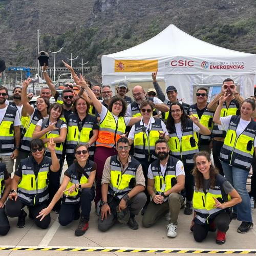
Upon arriving in Garachico, we went directly to the Advanced Command Post (PMA), which, according to the PEVOLCA (the Volcanic Risk Management Plan of the Canary Islands), is the coordination center where all operational groups gather during a volcanic emergency. The PMA is usually installed as close as possible to the source of the emergency, but always in a safe area for personnel working on site. In this case, it was set up at Garachico’s New Pier, where tents, vehicles, and containers were deployed, equipped with everything needed to carry out emergency operations.
The main teams present at the PMA included:
• The Tenerife Island Council (Cabildo)
• The Fire Department
• Emergency Services 112 Canarias
• The Advisory Group for Disasters and Emergencies (GADE) of the Spanish National Research Council (CSIC)
• The National Geographic Institute (IGN)
NRAMS joined the GADE-CSIC. During an emergency, GADE is responsible for providing scientific and technical advice, deploying different expert teams to the field depending on the type of natural hazard involved. In this case, teams specialized in drones, volcanology, ground deformation, remote sensing, social risks, geographic information systems, marine impacts, and cultural heritage, among others, participated.
On Wednesday afternoon, GADE members received training on the TETRAS (Terrestrial Trunked Radio) communication system, a device that enables secure communication among emergency services. In a real volcanic eruption, it is essential for teams operating outside the PMA to carry a TETRA device to ensure communication in case of mobile network failure. Afterwards, GADE’s occupational risk prevention officer conducted a short session on the main safety risks to consider during fieldwork.
At 8:00 p.m., GADE held its daily meeting. In real situations, these meetings are convened at the end of each day so that the leaders of the different scientific teams can report on the tasks carried out and the results obtained. They are confidential, practical, and solution-oriented. Afterward, each leader completes their section of a collective report, which the next day allows GADE’s emergency coordinator to communicate the GADE’s scientific progress to other scientific institutions within the Scientific Committee. The goal of this committee, as defined in PEVOLCA, is to reach a scientific consensus before passing information to the Advisory Committee, which includes political authorities and safety experts who must make strategic decisions.
This cascading structure of meetings enables continuous updates and helps adjust decisions to the evolving situation. It also demands extensive communication and coordination among different sectors, all working toward a common goal: to minimize the impact of natural hazards resulting from a volcanic eruption.
Thursday, September 25
On Thursday, the day before the drill, NRAMS actively participated in the discussion tables organized by the Chair of Disaster Risk Reduction and Resilient Cities of the University of La Laguna and the Tenerife Island Council. The aim was to use the simulation as an opportunity to evaluate the Insular Action Plan for Volcanic Risk in Tenerife (PAIV), which adapts the PEVOLCA framework to the specific context of Tenerife.
There were three main discussion areas: Evacuation, Shelter, and Public Communication. The sessions were held over Wednesday and Thursday, working separately in the mornings and coming together in the afternoons to share conclusions. The event took place in two of Garachico’s most emblematic historic buildings: the Convent of San Francisco and the House of the Counts of La Gomera (Casa de Piedra).
NRAMS took part in the Communication table, which on Thursday focused on developing communication strategies for a scenario in which an eruption was imminent and an evacuation needed to be communicated to the public. Participants included representatives from the Official College of Psychology of Santa Cruz de Tenerife, local police, Red Cross, media (RTVC and TVE Canarias), and technical staff from the island’s tourism, education, and volunteer departments. Each participant contributed their perspective on the communication needs of their sector.
At around 5:00 p.m., NRAMS returned to the PMA and later attended another GADE-CSIC meeting. Throughout the day, CSIC’s various scientific groups carried out field activities such as bird censuses, fracture inspections, and air quality measurements. The oceanographic vessel Ramón Margalef was also simulated to arrive, as it would in a real event, to collect bathymetric and physico-chemical data from the surrounding waters.
Friday, September 26
Drill day. From early in the morning, Garachico was bustling with activity. The PMA was fully operational, and several guaguas (buses) arrived in the municipality to prepare for the evacuation exercise.
The simulated eruption officially began at 10:00 a.m., but at 9:00 a.m., mobile phones in Garachico received the first ES-ALERT message with instructions on how to proceed with the evacuation (what to bring, meeting points, and recommendations for people with pets). Twenty minutes later, a second message was sent clarifying that the situation was part of a simulation.
During the day, NRAMS worked with GADE-CSIC’s Social Risks group, conducting surveys among residents to understand how they experienced the drill, their level of preparedness for a potential eruption, and the vulnerability of Garachico’s cultural heritage. Conducting face-to-face interviews also allowed the team to collect valuable qualitative insights about how the simulation was perceived locally.
Meanwhile, various parallel activities took place around Garachico:
• Emergency and medical vehicles, sirens blaring, circulated along the town’s narrow main road.
• Local police and Civil Protection managed pedestrian and vehicle traffic.
• A large tent was set up at the Old Pier by the Red Cross and Civil Protection to assist evacuees, who were then transported by bus to the New Pier.
• A simulated accident between a bus and a car was performed, involving professional actors and actresses.
• Schools and nursing homes in the nearby town of El Tanque were placed under confinement.
• The Military Emergency Unit (UME) removed valuable cultural artifacts from churches and distributed emergency food kits.
• Daily meetings took place at the PMA, and a press table was set up for live updates.
• In the town centre of Garachico, several screens broadcast the press conference and information on lessons learned from the La Palma volcanic eruption.
• GADE teams tested procedures for ash sampling, isopach map production (ash accumulation according to wind distribution), drone flights, and air quality analysis, among others.
At 1:11 p.m., another ES-ALERT message announced the end of the drill. Shortly afterward, teams began to pack up their equipment.
Before returning to the PMA, there was an opportunity to visit the CajaCanarias Cultural Space, which hosted an exhibition on the volcanism of the Canary Islands, including drawings of volcanoes made by schoolchildren. The exhibition was part of the outreach activities organized within the framework of the drill. The week before, training workshops had also been held for residents, which were very positively received. Many expressed that they should be replicated in other municipalities.
Finally, on the way back to the airport, driving a small Fiat 500 along the TF-5 road, the volcanic origins of Tenerife’s landscape were unmistakable: the winding road followed the topography of the La Orotava and Icod valleys, formed by massive landslides during caldera collapses and associated seismic activity of Las Cañadas volcanic edifice, later filled by successive lava flows. Tenerife never fails to impress, especially after witnessing a drill of this scale. We hope the island’s volcanic systems remain calm for a long time. In the meantime, it is essential to stay well prepared and to strengthen trust between the population and the teams responsible for volcanic risk management. At NRAMS, we view these exercises very positively, as they help reinforce both preparedness and public confidence.