Risk Data Hub Analytical Reports
The Risk Data Hub hosts disaster loss and risk data on a GIS web platform to support evidence-based disaster risk management activities in Europe.
The Risk Data Hub hosts disaster loss and risk data on a GIS web platform to support evidence-based disaster risk management activities in Europe.
The Risk Data Hub (RDH) is Geographic Information System web platform for the documentation, evaluation and sharing of disaster risk, damage, and loss data on a European scale, with the aim of supporting disaster risk management activities in the region. The platform hosts available and commonly used data on risk components, such as hazard, exposure, and vulnerability, which can be used for risk analysis. Additionally, the disaster loss module offers loss and damage data like the number of fatalities or economic and non-economic losses for further analysis. Developed and hosted by the European Commission’s Disaster Risk Management Knowledge Centre, the RDH is available to the general public as well as specialised users alike.
The data available on the platform supports evidence-based decision making and enables a combined perspective on international policy and local practice and implementation.
The analytical report "Evidence for disaster risk management from the Risk Data Hub" published by the JRC presents five possible applications for the data available on the RDH. The report outlines, for example, how the data hosted on the RDH platform allows to examine historical trends and current risk levels for single hazards. It also demonstrates how it can be used to identify regions with multi-hazard potential, emerging or increasing risks as well as drivers of vulnerability and disaster risk.
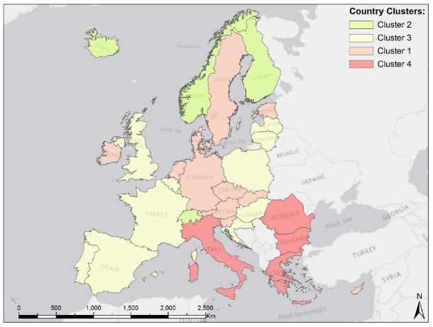
On a European scale, the vulnerability framework of the RDH can be employed, for example, to compare levels and trends of vulnerability among countries, revealing possible spatial patterns across the continent. Countries can be grouped into categories of stable or increasing low, medium, and high vulnerability levels. This then allows to identify common factors affecting vulnerability across borders.
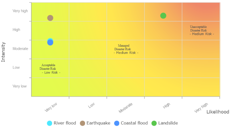
Finally, the analytical report outlines how the RDH can be used to create country specific reports on risk, disaster loss and their individual components at different spatial aggregations. This can then be used to create risk matrices for different assets, such as critical infrastructure, the environment or population due to a specific hazard. It also allows to examine the components of vulnerability and their contribution to the overall vulnerability index of the country.
In addition to these data sets, the platform also hosts external projects in its so-calles "User Corner". The outcomes of these projects may extend the RDH to geographical or thematical areas not initially covered by the disaster risk and damage data available. Examples of such projects are the European Central Bank Physical Risk indicators or the Flood Fatalities for Territories in the Euro-Mediterranean Region database.
To support users in familiarising themselves with the functionalities of the Risk Data Hub, materials from a dedicated workshop are available on the DRMKC website here.
Sectors