FSX Magnitude: Earthquakes in Baden-Württemberg, Germany
Earthquake
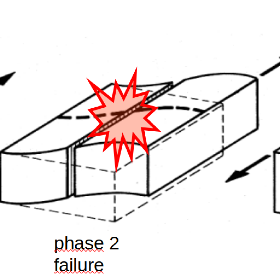
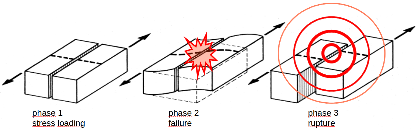
An earthquake is caused by a sudden release of tectonic shear stresses, resulting in the displacement between two solid blocks of rock and the radiation of seismic waves (see Fig. 1). The strength of the earthquake is measured in magnitudes, commonly quoted as the Richter Scale. While the magnitude is a physical parameter of the source, the effects of the earthquake on people, buildings, infrastructure and landscape are described by the macroseismic intensity. The scenario of the MAGNITUDE exercise refers to the European Macroseismic Scale (EMS-98).
Earthquakes are unpredictable, especially the time of their occurrence cannot be calculated in advance. However, a rough estimation of the largest expected magnitude and its return period is possible, as far as the regional tectonic settings and the rate of stress load are known. This enables the preparation for potential future earthquakes by means of building specifications and emergency response plans.
The vast majority and the largest earthquakes worldwide occur on the margins of tectonic plates. They are referred to as „interplate earthquakes“. However, stresses caused by plate movements and other local tectonic effects can lead to earthquakes far away from plate boundaries. They are referred to as „intraplate earthquakes“ and are commonly smaller and rarer than interplate events.
Germany is not located on a tectonic plate boundary. The collision zone between the Eurasian and African plates is located beneath the Alps. But further dispersed stresses of the ongoing collision still influence tectonic faults far north of the Alps and into southern Germany.
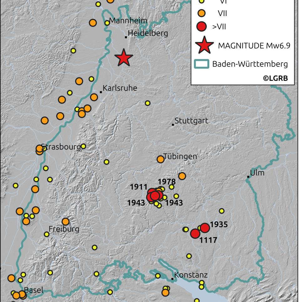
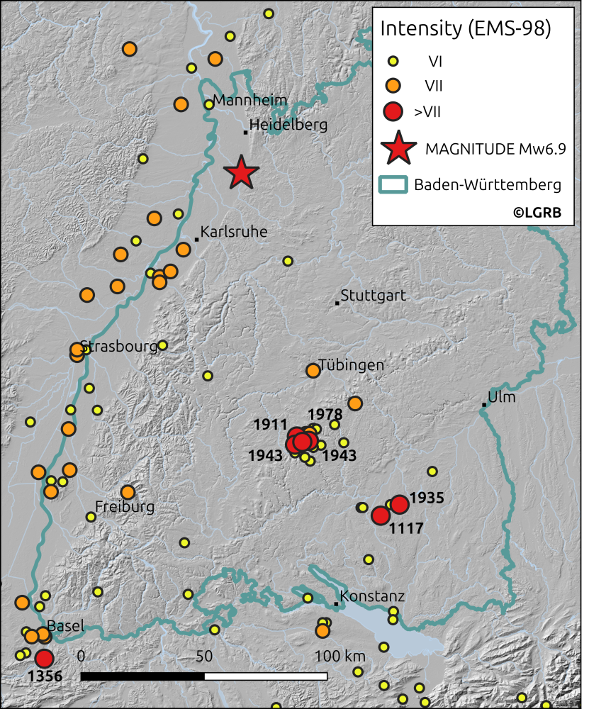
Baden-Württemberg is among the seismically most active states in the Federal Republic of Germany. Located in the very southwest of the country, the most prominent active structures are the Upper Rhine Graben and the Swabian Alb (Albstadt Shear Zone). Instrumentally measurable earthquakes are observed daily in Baden-Württemberg. Locally up to regionally felt events occur on average once per month. Stronger earthquakes that affect buildings and infrastructure are observed about once per decade. Catastrophic events are rare, but cannot be excluded. Historically, earthquakes of magnitudes larger then 6, occasionally up to 7 have been documented. Their intensities reached up to IX on the EMS-98 scale (see Fig. 2 and earthquake catalogue of Baden-Württemberg).
Summarising, the earthquake hazard, i.e. the chance of a devastating earthquake in Baden-Württemberg, is much lower in comparison to countries located on tectonic plate boundaries. But the dense population and complex industrial infrastructure nevertheless pose a non-neglectable risk to the region in case of a large seismic event.
The energy release, the so called seismic moment, is mainly controlled by the extension of the fault plane and the displacement on that plane. Thus, the maximum magnitude is limited by the extension of tectonic structures, allowing a rough approximation of the largest expected earthquake in a certain tectonic setting.
The largest tectonic feature in Baden-Württemberg and neighbouring countries (Switzerland and France) and federal states (Rhineland-Palatinate and Hesse) is the Upper Rhine Graben, a formerly active rift extending about 300 km from around Basel (Switzerland) to the north-northeast to Frankfurt am Main (Hesse). The Upper Rhine Graben hosts several subparallel faults, both along its borders and in its interior. Regarding their extensions and according to the current state of science, these faults can host earthquakes of a maximum magnitude of 7 or slightly above. The largest historically documented event is the Basel earthquake of the year 1356, with an approximate magnitude of 6.5 to 7 and a maximum intensity of IX.
This size of event was exemplarily used as the scenario of the MAGNITUDE exercise, which assumes a magnitude 6.9 earthquake in 10 km depth on a 40 km long rupture plane on the eastern border fault of the Upper Rhine Graben, between the cities of Heidelberg and Karlsruhe. Using the ShakeMap modeling software of the USGS Hazard Program, the shaking intensity according to EMS-98 can be calculated (see Fig. 3).
Intensity is strongest in the vicinity of the epicenter and declines with distance. It is on average stronger in unsolidated sediments, such as the Rhine Graben, compared to mesozoic or crystalline rocks, such as the Black Forest. A Magnitude 6.9 earthquake in Baden-Württemberg would be felt in whole Central Europe. Damages could be expected in an approximately 100 km radius around the epicenter, occasionally beyond. The maximum intensity in the epicentral region could reach IX (nine), resulting in the following effects on the surface (for details on building classes and damage grades see the EMS-98 scale and references therein):
- The earthquake will cause general panic among the public.
- People may loose balance and can be forcibly thrown to the ground.
- Depending on their building class, many buildings can sustain structural damages up to total collapse. While modern buildings are constructed according to earthquake-adapted building codes to mitigate impact, older houses (especially rubble stone and bricks) are more prone to severe damage.
- Many monuments and columns fall or are twisted.
- Surface waves of the earthquake are seen on soft ground.
- Geological impacts, such as rock falls, landslides or ground liquefaction, can complicate rescue operations.
- Damaged bridges and roads can impede access to the disaster zone.
Despite of the impact of the main shock, aftershocks have to be expected for the following days, weeks and months. Their magnitudes are generally smaller, but it cannot be excluded that they cause further damage to already structurally affected buildings and infrastructure. Similar to the main earthquake, aftershocks will come without any advance warning and thus pose further challenges to rescue operations.
The responsibility for earthquake monitoring in Germany lies with the federal states. The source region of the here exercised earthquake is monitored by the State Seismological Survey of Baden-Württemberg. The dense monitoring network consists of about 50 seismic sensors and measurements are completed by data of neighbouring institutions: LER from Rhineland-Palatinate, HLNUG from Hesse, as well as the French RéNaSS and the Swiss SED. Waveform data are sent in real time to the data center in Freiburg, automatically analysed and manually revised by seismologists. Detected earthquakes generate automatic alerts that are sent to the situation room of the State Ministry of the Interior in Stuttgart, which is manned 24/7. A preliminary automatic solution, i.e. location and magnitude of the earthquake, is available within 3-4 minutes. The direct and efficient communication channels between the Seismological Survey and authorities allow a fast emergency response and timely information to the public.
Dr. Martin Hensch, Dr. Andrea Brüstle, Dr. Stefan Stange
State Seismological Survey of Baden-Württemberg
Regierungspräsidium Freiburg
Fig. 2: Map of damaging earthquakes (EMS-98 intensity of VI or higher) for the last 1000 years according to the earthquake catalogue of Baden-Württemberg. Red dots mark earthquakes of intensity larger than VII including their year of occurrence, orange dots stand for intensity VII and yellow for intensity VI. The red star gives the position of the Mw6.9 MAGNITUDE exercise earthquake, with a maximum intensity of IX. (base map: https://doi.org/10.5270/ESA-c5d3d65)
Fig. 3: ShakeMap of the MAGNITUDE scenario. An earthquake of magnitude 6.9 occurs on the eastern border fault of the Upper Rhine Graben at 10 km depth between the cities of Karlsruhe and Heidelberg. Macroseismic intensities according to EMS-98 are colour-coded from cold (weak) to warm (strong). The maximum intensity of the exercise scenario is expected around IX.
Full-Scale Earthquake Response Exercise in the cross-border-region of southwest Germany.