You are about to be redirected to EU Login, our authentication service.
The UCPKN platform offers different kinds of information views based on the identification of the user, and its associated roles. If it is the first time you are logging in to the platform, your profile will be validated at the end of the process, and you will receive a label and/or associated roles on the platform based on the information provided by you.
If you are a civil protection expert active in the context of the Union Civil Protection Mechanism operations (e.g., training, exercises, deployments), make sure you are using the same email address you used for training/deployment registration for a proper creation of your profile.
Prevention and preparedness from a Sicilian community perspective
Published on
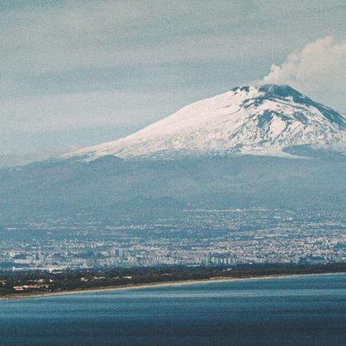
Mount Etna is an active volcano towering over the town of Catania, in Sicily - the highest in Europe and a top destination for tourists throughout the year. This iconic symbol also presents challenges in the area of disaster risk management, highlighting the need to improve community preparedness.
By Knowledge Network – Staff member
By Valentina Amato, co-founder of 350 Sicilia
Mount Etna: tourist attraction or natural hazard?
Valentina Amato (former trainee at DG ECHO) has spent most of her life near Mount Etna, and co-runs 350 Sicilia, an international Sicily-based association focused on climate justice and environmental preservation.
Here she speaks to Domenico PATANÈ, Director of Research at the National Institute of Geophysics and Volcanology - Etna Observatory, Gabriele AMATO,PhD Student at the University of Catania, Department of Biological, Geological, and Environmental Sciences, and Ida JUNGBLUT,Master's Student in Geology and Geophysics at the University of Catania, who provided us with valuable information on how volcanic eruption emergencies are managed, offering insights from various angles and voices of those working or studying locally in this field.
This image portrays Catania during Mount Etna’s 1669 eruption, illustrating the impact of the volcano on the city and its surroundings. Picture credits: Ida Jungblut.
What tools and strategies are used to monitor volcanic activity and protect communities and infrastructure? How are these activities integrated into emergency and evacuation plans?
Patanè D.: Mount Etna, one of the most active volcanoes in the world, is constantly monitored by the Etna Observatory of the National Institute of Geophysics and Volcanology (INGV-OE) through an integrated network of seismic sensors, GPS, geochemical instruments, cameras, drones, and satellites. These systems enable the early detection of signs such as ground deformation, gas variations, and seismic activity, often associated with the ascent of magma from deep within the Earth.
A notable recent example is the eruption on 24 December 2018, which was preceded by a seismic swarm culminating in a magnitude 4.8 earthquake with its epicentre in Viagrande, causing damage in the municipalities of Trecastagni, Fleri, and Zafferana Etnea.
Amato Gabriele: Volcanic monitoring is conducted in various ways, including ground deformation study and Geochemical monitoring, based on this, hazard maps of Mount Etna are created to determine the potential impact of eruptions and ash clouds on nearby populated areas. These maps are provided to Civil Protection authorities, which in turn develop evacuation plans accordingly.
Patanè D.: The evacuation plan for communities near Mount Etna is coordinated by the Civil Protection and is based on risk scenarios developed with INGV. The most exposed areas, such as parts of Zafferana Etnea, Nicolosi, and Belpasso, are classified as "red zones" and require rapid evacuations in the event of an imminent eruption. More distant areas, still vulnerable to ashfall, are included in the "yellow zone", where measures like school closures or traffic restrictions are implemented. The alert system is structured into four levels (green, yellow, orange, red) and includes official communications from INGV and Civil Protection. The entire plan aims to ensure a swift and effective response, minimising risks to the population.
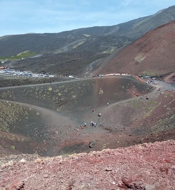
Mount Etna in autumn, seen from Rifugio Sapienza, with the Silvestri Craters nearby. Picture credits: Valentina Anna Amato.
All these measures are part of a coordinated monitoring and intervention system, led by INGV and Civil Protection, to ensure the safety of hospitals, schools, transport, and other essential services
Domenico Patanè, the National Institute of Geophysics and Volcanology
A history of human resilience and climate adaptation.
Nowadays, eruptions typically last several days and are often characterised or followed by lava spurts and flows, falling black ash, and earthquakes, sometimes with loud ‘booms’. These events pose various risks, and air traffic is usually suspended or interrupted depending on how the eruption evolves.
Patanè D.: In recent decades, Etna has shown an increase in the frequency of lava fountains, particularly from the Southeast Crater. Since 2011, the volcano has produced dozens of paroxysmal episodes, with fountains several hundred metres high, often accompanied by massive ash emissions, lava overflow, and infrasound waves detectable at long distances. Although this eruptive activity is localised to the summit craters, it can generate ash emissions capable of reaching populated areas and Catania airport, affecting mobility and public health. Systems like the ETNAS alert system and INGV's VONA bulletins are crucial for anticipating and managing these phenomena.
To protect critical infrastructure from volcanic activity, both preventive and emergency measures are adopted. Artificial barriers and trenches are used to divert lava flows, as demonstrated during the 1983 and 1992 eruptions; in the latter case, they managed to slow or redirect lava threatening Zafferana Etnea. Another significant case is the 2001 eruption, when a flow stopped just 4 km from Nicolosi, highlighting the importance of planning and continuous monitoring in exposed areas.
Ash, however, poses a more widespread and unpredictable threat: it can damage power lines, pipelines, engines, and weigh down structures like roofs and roads. Particular attention is given to Catania airport, often affected by ashfall, leading to flight suspensions or restrictions. In such cases, emergency plans involve rapid runway cleaning and, if necessary, temporary closure of the airport, based on VONA system guidance.
Jungblut I.: There is relatively low awareness of the associated hazards and potential impacts of ashfall. The absence of preparatory actions proves costly in terms of restoration time, delays in key decisions by authorities, and ultimately the damage incurred.
The INGV releases public notices to inform the population about ongoing volcanic activity, its intensity, and potential impact, as was the case during the latest eruption in August 2025. These notices result from continuous monitoring, with details presented in weekly bulletins that outline potential scenarios based on collected data, volcanological observations, and measured parameters. Complementary to this, the Regional Civil Protection regularly issues announcements on its website and social media channels to provide up-to-date information on volcanic activity, associated risk levels, and the accessibility of affected areas.
The INGV additionally published a recent study where researchers analysed thousands of earthquakes beneath Mount Etna, showing that volcanic magma further amplifies local seismic risk by interacting with pre-existing faults [Scarfì, L., Barreca, G., Cassisi, C. et al. Earthquake clustering and structural modelling unravel volcano-tectonic complexity beneath Mount Etna.
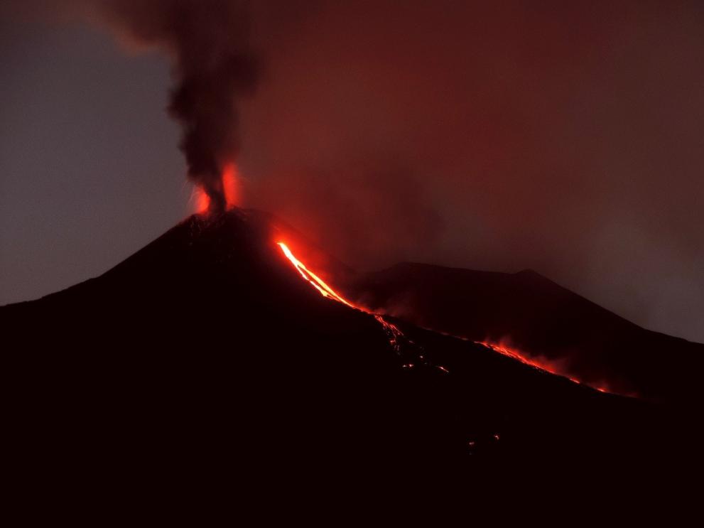
Eruption of Etna’s South-East Crater with Strombolian activity and lava flow, 12 August 2014. Photo courtesy: INGV. Picture credits: Boris Behncke.
Could the preparedness practices adopted on Mount Etna serve as a model for other volcanic contexts?
Amato Gabriele: What has been discussed so far is applicable to any open-conduit volcano like Mount Etna, especially concerning volcanic monitoring and hazard maps.
Patanè D.: Mount Etna serves as an effective model for volcanic risk monitoring and management, thanks to its advanced alert systems and the collaboration between institutions and the local population., Recent tragic events worldwide, such as the sudden and deadly eruption of Mount Ontake in Japan (2014) and those of Mount Semeru (2021) and Mount Lewotobi Laki-Laki (2024) in Indonesia, highlight the critical importance of maintaining vigilance, improving monitoring systems, and ensuring clear communication to protect lives in volcanic areas frequented by tourists.
Eruption-associated risk: normalised or underestimated?
When discussing the topic with locals, the risk is often normalised because it is part of their routine, and people tend to easily adapt to potential and more common shortcomings. This general behaviour can lead to overlooking major dangers if the scale of the eruption is greater - for example, the collapse of mountain walls or interactions between lava and snow, which can cause explosions.
Mount Etna, once considered mainly effusive, has produced frequent pyroclastic flows in the past 25 years. The most notable occurred on 2 June 2025, travelling nearly 3 km into the Valle del Bove (INGV). Despite the apparent increase in hazard, advances in monitoring technology allow experts and Civil Protection authorities to keep the situation under control, maintaining a careful watch over the volcano.
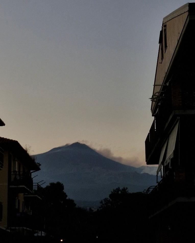
Mount Etna in eruption, viewed from the residential area of Tremestieri Etneo, Catania Province, August 2025. Picture credits: Valentina Anna Amato.
Do you believe that residents and tourists are adequately informed and prepared? What warning systems and educational campaigns are currently in place?
Amato Gabriele: I believe that more digital information points should be created to communicate effectively with all types of audiences.
Jungblut I.: Communication regarding the hazard and recommended mitigation steps should be transparent, repeated, and from multiple sources that are authoritative, credible, and trusted, as the challenge lies in effectively conveying this information to the population, especially since Mount Etna does not pose as high a risk as, for instance, Mount Vesuvius.
Patanè D.: The alert and communication system exists and functions, but the actual preparedness and awareness of residents and tourists also depends on factors such as education, participation, and continuous updates. Improvements are possible, especially in the direct involvement of people and practical training. Residents are generally informed, thanks to awareness campaigns and emergency plans shared with municipal administrations.
Preparing tourists is more challenging, as they are often present only for short periods and may not have access to or interest in risk information. Although information points and signage are active in tourist areas and at refuges on Etna, the level of awareness can be limited. Tour guides and local operators play an important role in conveying safety instructions. Various tools contribute to creating a coordinated prevention and response system, but their effectiveness also depends on the active participation of the community and the continuous updating of communication strategies.
There is still relatively low awareness of the risks linked to ashfall. The lack of preparation often translates into higher damage and slower recovery.
Ida Jungblut, University of Catania
How is tourist access managed during phases of volcanic activity? How is the balance between safety and tourist interest in Mount Etna achieved?
Amato Gabriele: Access to Mount Etna during phases of volcanic activity is restricted by the forest service and Civil Protection to areas deemed safe. It is possible to reach the lower slopes of the volcano to admire the eruptions safely, but access is halted beyond certain elevations.
Patanè D.: During phases of eruptive activity on Mount Etna, tourist access is regulated through a system of municipal ordinances and safety measures coordinated by the Sicilian Civil Protection. These regulations establish safety zones and limit access to certain areas to prevent health and public safety risks.
However, recent incidents have highlighted some challenges in managing tourist influx. For instance, during the February 2025 eruption, thousands of tourists headed to the volcano, causing road congestion and potentially hindering rescue operations. Another significant case was the June 2025 eruption, which saw a partial collapse of a part of the Southeast Crater, one of the most active in recent years. Despite the intensity of the event, no injuries were reported.
How the UCPM works on managing and understanding volcano risks
The UCPM (Union Civil Protection Mechanism) framework supports initiatives focused on volcanic risk assessment and preparedness. It highlights a collaborative approach to managing and understanding volcanic risks.
A notable example is the VOLCAN project (TRACK 1, 2025-2026), which exemplifies joint efforts to advance volcanic risk management in the Canary Islands. The project contributes to the revision and enhancement of the Canary Islands’ volcanic disaster risk management plan by integrating advanced hazard assessments, early warning systems, risk reduction policies, and public awareness and training programmes to improve preparedness, response, and resilience against future eruptions.
Southeast Crater of Etna erupting on the evening of Dec 1, 2023, as seen from Piano San Leo. Picture credits: INGV.
It is exciting to witness the growing interest in Mount Etna, a natural wonder that continues to attract global attention while remaining a source of identity and belonging for Sicilians.
Valentina Anna Amato
With big thanks to:
Domenico PATANÈ,
Director of Research at the National Institute of Geophysics and Volcanology - Etna Observatory.
Gabriele AMATO,
PhD Student at the University of Catania, Department of Biological, Geological, and Environmental Sciences, supervised by Dr. Andrea Cannata. He has a previous specialisation in geo-resources, volcanic risk, and seismic risk.
Ida JUNGBLUT,
Master's Student in Geology and Geophysics at the University of Catania.
By Valentina Anna AMATO, Blue Book Trainee ECHO B.3 March-July 2025
Former tourist guide for the Volcanological Museum of Etna (Volcano House Etna), Nicolosi, Catania,
350 Sicilia is the first local group in Italy of the global non-governmental organisation 350.org. Focused on promoting the transition to renewable energy for a green future, the association encourages sustainable environmental practices and raises awareness of the consequences of climate change on people and the planet, while also addressing them through prevention and preparedness. Its activities include participation in community events such as conferences, clean-ups, debates, workshops, creative spaces, and engagement through digital platforms.
The Preparedness Union Strategy emphasises youth risk awareness, to be developed through school programmes and international experiences (Erasmus +, European Solidarity Corps). 350 Sicilia contributes by interacting with, and building connections between, young people and regional Civil Protection representatives, helping to fill information gaps about the risk landscape at local, national, and global levels through simulations, visits, and monitoring activities - e.g., by helicopter. By equipping people with the right skills and tools to respond to emergencies, the association empowers them to become agents of change. Therefore, it also intends to initiate or contribute to projects eligible under the Erasmus+ and ESC funding programmes.
The Knowledge Network editorial team is here to share the news and stories of the Knowledge Network community. We'd love to hear your news, events and personal stories about your life in civil protection and disaster risk management. If you've got a story to share, please contact us.