The science in the EU response in Türkiye & Syria
The Joint Research Centre (JRC) and the ERCC have been supporting the response to the earthquakes in Türkiye and Syria.
EarthquakeEnvironmentalGeohazards
The Joint Research Centre (JRC) and the ERCC have been supporting the response to the earthquakes in Türkiye and Syria.

By providing an integrated scientific perspective and regularly updated information, the European Commission’s Joint Research Centre (JRC) and the ERCC have been supporting decision-making at both political and on-the-ground levels since day one of the emergency in Türkiye and Syria.
Thirty-two minutes after the first earthquake, the Global Disaster Alert and Coordination System emitted a red alert to warn the humanitarian aid community that international assistance would likely be necessary to cope with a major disaster. Soon after, Türkiye reached out to the ERCC. The centre activated the UCPM – initially requesting USAR teams – and activated the Copernicus Emergency Management Service (CEMS).
Soon after, based on needs highlighted by the ERCC, ECHO Daily Maps were developed to provide information on the impact of and response to the event. The JRC’s Disaster Risk Management team established an internal group to exchange resources, expertise and news. This group produced several emergency reports which were sent to ECHO and ARGUS, a Commission-wide information and communication tool to support the crisis management and coordination mechanism.
These reports showed and/or modelled possible – or already happening – damage to the built environment, post-disaster scenarios such as dam breaking, migratory consequences and misinformation trends and the health situation (current cholera outbreaks and monitoring for other possible health issues) in affected areas.
Particularly relevant work shared in these reports was performed by the Social Media for Disaster Risk Management (SMDRM) AI algorithm, which processed more than 1 million user-generated messages on Twitter to identify messages requesting help. Specific location information was georeferenced and shared to help rescuers prioritise areas in which to look for survivors.
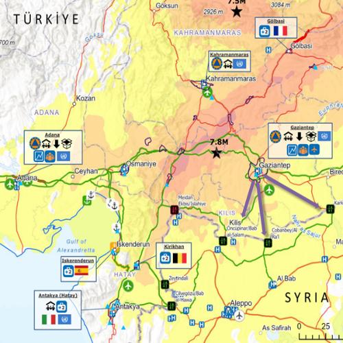
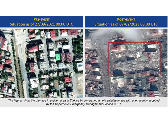
In less than 48 hours, CEMS started delivering the first maps of the event, identifying the infrastructure – buildings, dams, or gas and oil pipelines – affected. Other maps showed the situation in flood-prone areas the location of humanitarian camps. A report by the CEMS Drought Observatory showed that Türkiye and the Maghreb region are under warning of drought conditions. The compound effects of the earthquake and the drought may worsen water availability for agriculture and energy.
The Knowledge Network editorial team is here to share the news and stories of the Knowledge Network community. We'd love to hear your news, events and personal stories about your life in civil protection and disaster risk management. If you've got a story to share, please contact us.
Sectors