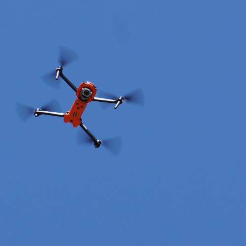
Drones and other UAV (unmanned aerial vehicles) are a game changer when it comes to disaster (risk) management – they can gather data, monitor threats, provide light, deliver aid, and much more. Thus, several EU-funded projects are working on both new UAV solutions as well as – in the case of COLLARIS2 – on building strong networks of drone experts and making sure the existing barriers for drone use can be overcome. A recent COLLARIS2 deliverable provides an overview of selected EU-funded projects in this field – both within the Union Civil Protection Mechanism (UCPM) and other EU funding programs such as Horizon Europe – and the project is happy to share a concise summary of the deliverable in this news story., i.e., short descriptions of projects COLLARIS(2) has already been collaborating with (or is hoping to do so in the future).
AIDERS - Real-time Artificial Intelligence for DEcision support via RPAS data analyticS
Funded by the UCPM and concluded in October 2022, the AIDERS project aimed to develop application-specific algorithms and a novel mapping platform that harnesses the large volume of data that first responders are now able to collect, and convert it into actionable decisions for improved emergency response. AIDERS achieved its objectives through four main outputs, namely: 1) knowledge on the potential use of artificial intelligence (AI) techniques and algorithms for acquiring valuable incident information; 2) a novel AI toolkit to provide relevant, reliable and timely information from the available aerial sensor data; 3) field exercises to evaluate the integration and performance of the AI toolkit; and 4) training activities for first responders. AIDERS is an open-source solution, available to be used freely by all interested stakeholders.
Find out more about the project here.

CoSky - Polish-Norwegian bilateral initiative for increased efficiency of use of drones in civil protection
Running from October 2024 to February 2025, this project was funded under the Program "Internal Affairs", implemented within the framework of the Norwegian Financial Mechanism and the EEA Grants 2014 – 2021. CoSky aimed to enhance the efficiency of drone use in civil protection in Poland and Norway by exchanging experiences and best practices in two key areas: coordination of complex air operations (involving both drones and manned aviation) and generating and sharing maps based on drone data. In Poland, the Polish Air Navigation Services Agency and the Crisis Information Centre CBK PAN in cooperation with the State Fire Service have undertaken a series of activities to develop and validate an innovative model enabling safe and effectively coordinated flights by both types of aviation during crisis operation. This model introduces the roles of Air Operations Coordinator and Flight Manager who are supported by the dedicated “Search & Help” (S&H) IT system enabling efficient communication with UAV pilots. During the project, operational tests of the S&H system were conducted, comparing it with Norwegian solutions such as NINOX and HemsWX. A key element was the analysis of experiences from Polish and Norwegian rescue operations, including the floods in Poland in September 2024. The project also addressed the topic of rapid UAV mapping, analyzing experiences from events such as the Gjerdrum landslide in 2020, where drones provided the first 3D map just 18 hours after the disaster. The project issued recommendations for integrating drone data with GIS and crisis management systems. Additionally, an e-learning course on UAV mapping for crisis management was created, available in Polish, Norwegian, and English. The final outcome of the project was a three-year roadmap outlining the development directions for air traffic management (ATM) and UAV mapping in Poland, including perspectives for further bilateral cooperation with Norway.
Find out more about the project here.
CREXDATA - Critical Action Planning Over Extreme-scale DATA
Funded by the European Union’s Horizon Europe programme until December 2025, CREXDATA will develop a generic platform for real-time critical situation management including flexible action planning and agile decision making over streaming data of extreme scale and complexity. The project will develop the algorithmic apparatus, software architectures and tools for federated predictive analytics and forecasting under uncertainty. The envisioned framework boosts proactive decision making providing highly accurate and transparent short- and long-term forecasts, explainable via advanced visual analytics and accurate, real-time, augmented reality facilities. To achieve its vision, CREXDATA will develop a next generation Prediction-as-a-Service (PaaS) system where action planners will easily register their multimodal data stream sources and compute resource federations and graphically design predictive analytics workflows.
Find out more about the project here.
DIREKTION - Disaster Resilience Knowledge Network
DIREKTION has received funding from the European Union’s Horizon Europe research and innovation programme and will run until September 2026. The project aims to sustainably establish a network in the community of disaster resilience that will enhance the exchange and consolidation of knowledge, promote innovation, technology uptake as well as multi-stakeholder cooperation targeting European needs and objectives. DIREKTION will connect practitioners and stakeholders as a network of networks, bringing together well-established fire & rescue organizations with academics, research organizations, industry and policymakers. To achieve this goal, DIREKTION will develop mechanisms and procedures to perform activities supporting the network mission: Identification of capability needs and gaps, technology screening and sourcing, technology and project results assessment, co-development of technologies, research programming and useful practitioner-oriented standardization.
During the CERIS event in March 2025, a dedicated Policy Brief called “Strengthening Responder Technology in Disasters” prepared by 17 EU-funded projects (including COLLARIS) was formally presented. It sets out practical recommendations to ensure that research and innovation (R&I) directly translate into effective, usable, and scalable solutions for emergency responders.
Find out more about the project here.
OVERWATCH
OVERWATCH has also been funded in the Horizon Europe Programme and will run until April 2026. Leveraging on the state-of-the-art approach, OVERWATCH will design and develop a backend management platform that will cover the whole lifecycle of data management going from the data ingestion, harmonization, standardization, and data processing into exploitable information. The backend management platform will allow collaboration of different kinds of users, with different roles that will manage information sources, exploit new ones or integrate other crisis management systems in order to have a cooperative system that will provide a comprehensive crisis overview. The solution will support emergency and crisis management covering a wide range of situations, proactive approach and insightful guidance will contribute to shape the right implementation plan suitable to the needs of the different audiences Overwatch is addressing.
Find out more about the project here.
PreViS 2 - Prehospital Video in Collaboration 2
PreViS 2 builds on PreVis 1, an earlier Interreg Sweden-Norway project, and will run until July 2026. The main goal of PreViS 2 is to develop and implement advanced video technology for decision support. At the same time, a triple-helix environment will be established that contributes to the long-term development of a comprehensive prehospital value chain. This will be done by developing and implementing video as a decision support, testing how innovative technology can be included in a comprehensive solution, and expanding the scope of use for video in the emergency chain to inter-municipal use and between emergency services. In addition, the project will stimulate the establishment of long-term R&D collaborations across business, academia and the public sector with the goal of contributing to the development of a robust emergency chain both in the hinterland and across national borders.
Find out more about the project here.
SYNERGISE
SYNERGISE stands for “A novel integrated SYstem of Systems streNgthening tEchnical and logistical capacities to ensure better Response to emerGencies by synergIStically addrEssing First Responders capability gaps” and is jointly funded from the European Union's Horizon Europe research and innovation programme, State Secretariat for Education, Research, and Innovation; R2 Network from the United States; the Japan Science and Technology Agency; the Korea Ministry of Science and ICT, and the Korea Electronics and Telecommunications Research Institute. The project’s duration is September 2023 – February 2027.
The project will boost the efficiency and safety of first responders during life-saving missions, the SYNERGISE team will develop a Novel Integrated Toolkit for Collaborative Response and Enhanced Situational Awareness (NIT-CRES). The toolkit shall improve the management of natural and man-made disasters whilst boosting collaboration between first responders to increase mission effectiveness and victim detection at highly challenging and complex incident sites. Besides first responders, the SYNERGISE team involves academic and research organisations that will provide leading-edge technology and small and medium companies that will develop key innovative components and commercialize the Novel Integrated Toolkit. First response practitioners will take care of the testing, training and validation at component and toolkit levels in the framework of a rich Integration, Testing and Validation Activities Programme. International relief practitioners will be involved as members of the project’s Advisory Board, responsible for technology validation and wider outreach to the relevant stakeholders and capacity building.
Find out more about the project here.
Further projects of interest
In addition to the projects mentioned above, there are several other EU-funded initiatives relevant in the field of UAS and worth checking out – such as
- ForeSight - Improving last-kilometer navigation & transportation of emergency personnel, equipment and relief items in hazardous and challenging environments
- HURRICANE - Holistic UGV-based Resilient and Real-time Intelligence for Crisis And Natural Emergency
- TRIFFID - auTonomous Robotic aId For increasing FIrst responDers efficiency
- COURAGEOUS²
- TEMA - Trusted Extremely Precise MApping and Prediction For Emergency Management
- EUSOME - Enabling Autonomous Aerial Systems through Operational Methods and Techno-logical Enhancements
About COLLARIS2
The EU-funded project COLLARIS2 is the successor to COLLARIS (COLLaborative network on unmanned AeRIal Systems) and focuses on the use of UAS (e.g., drones) in the field of civil protection and disaster management. Building upon the results of the COLLARIS Network, this project aims to continue, expand and further develop the already established international network of crisis management and civil protection practitioners, research institutions and public administration. The members of the network collect and transfer knowledge, exchange experiences, skills, good practices and information on operational procedures for the optimal use of drones in crisis management and rescue missions.