In June 2025, the European Commission took a decisive step forward by incorporating data from its flagship Destination Earth (DestinE) initiative directly into the operational products of the Emergency Response Coordination Centre (ERCC) for the first time. This marks a turning point in how the EU anticipates and responds to disasters.
What is Destination Earth?
For those unfamiliar with the concept, DestinE is an ambitious EU initiative to develop highly accurate digital twins of the planet. DestinE is not just a model – it is a high-fidelity digital replica of the Earth, powered by petascale computing and AI-driven Earth system models.
Developed by the European Space Agency (ESA), the European Centre for Medium-Range Weather Forecasts (ECMWF) and the European Organisation for the Exploitation of Meteorological Satellites (EUMETSAT), DestinE aims to monitor and predict natural and human-induced phenomena with unprecedented precision. It provides interactive, scenario-based simulations for policymakers and crisis managers to support the Green Deal and the EU Digital Strategy.
First operational test: Nigeria flash floods 2025
The first real-world application of DestinE data for disaster risk management occurred during the flash floods in Nigeria, triggered by heavy rainfall on 29 to 30 May 2025. The floods devastated Mokwa, Niger State, claiming over 150 lives and displacing more than 3 000 people.
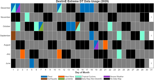
What began as an experiment quickly evolved into a sustainable practice. A review of the ECML team’s analyses from the second half of 2025 shows that Extremes DT data was used to produce 24 specialised daily maps covering different types of disasters such as floods, tropical cyclones and heatwaves. This growing adoption proves that DestinE is no longer just a visionary project – it is increasingly becoming an operational tool that strengthens the EU’s crisis response capacity.
This success is rooted in the close cooperation between the JRC, the Directorate-General for European Civil Protection and Humanitarian Aid Operations, the Directorate-General for Communications Networks, Content and Technology, and the teams of ESA, ECMWF and EUMETSAT, who jointly develop the components of Destination Earth. Their synergy enables analysts to work with interactive analysis combining real-time observations and cutting-edge Earth system modelling.
Looking ahead, discussions in 2025 focused on integrating the Global Disaster Awareness and Coordination System (GDACS)opens in new tab with DestinE data and automating tropical cyclone impact assessments. These advancements will allow the ERCC not only to visualise potential disaster zones at very high resolution during such an event but also to estimate needs in advance.
The floods in Nigeria were a tragic reminder of nature’s force, but the EU’s response showcased the power of innovation. Today, just six months later, Destination Earth is already shaping the future of civil protection.